
|
|
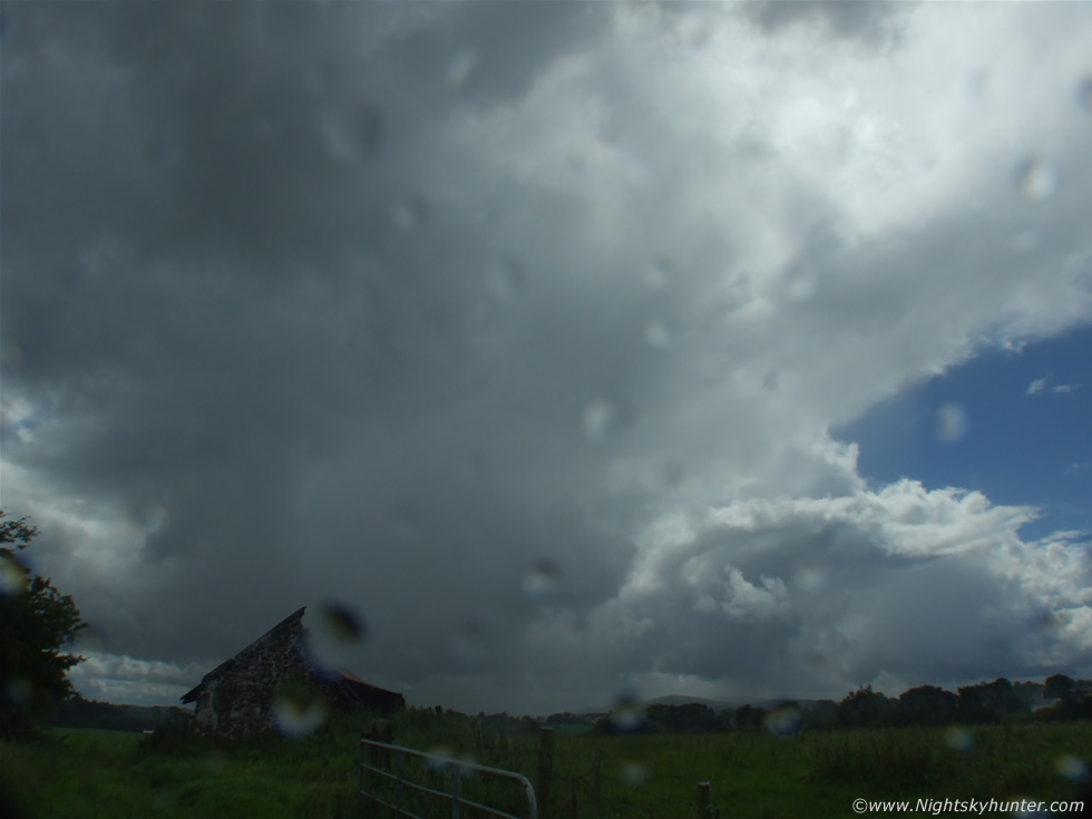
This was my second storm shoot from August 2nd 2008. This was one of those very unsettled classic convective days in this country when locals say ''we get all four seasons in the one day''. Heavy rain, gusts of wind, dark skies then clear, sunny then blue sky with intense sunshine. These are the kind of days I like because there's always something going on to photograph, even since the early morning large cumulus towers dominated the sky, they are known by many names: Towering Cumulus (Cu), Cumulus Congestus, or just Cu Towers, either way their presence during the early or late morning is a good sign for an interesting convective afternoon/evening to come. These clouds have a distinctive profile, the ones to watch have high vertical extent ending in well defined cauliflower-like plumes in their towers, look for height and a crisp/solid look and a well defined dark base. A tower leaning over is also a sign of strong wind shear which is a significant factor for long duration storms later. The cumulus is composed of a strong updraught only, in the most powerful examples the winds are rushing up through these clouds at about 100 mph, they sometimes lift a slab of air up with them called a Pileus Cap which is also a good sign. These clouds can produce heavy rain but more importantly they can drop funnel clouds which is why they are worth watching, if the conditions are correct with plenty of instability, solar heating, moisture etc then these Cu will form into the mega cumulonimbus cell.
These storm cells may grow from any individual cu tower, or a group of Cu will merge together and form a more organized system. The cumulonimbus (Cb) is the ultimate cell to watch, their distinctive anvil canopy make them stand out from everything else. Cbs are composed of an updraught and downdraught, they become a living breathing system so to speak and produce t-storms, heavy precipitation, large funnels and tornadoes. The very best have a rock solid updraught and anvil with a row of cu towers to their rear which keeps the storm fuelled for a longer period of time. Each new tower will take over and become the main updraught tower, then be replaced by the previous one, this process repeats itself until the cell becomes outflow dominant and decays. Groups of Cbs are known as multicells and feed off each other for a long period of time. Very often you will see lines of cu with perhaps one or two Cbs in that line. Seeing a clear blue sky around these is a good thing (and photogenic) because solar heating can still take place and fuel the convection. If the sky becomes completely overcast and grey before many Cbs form for a good length of time then heating of the ground will be cut off and the cells will decay. The late morning was the opposite of this, the cu towers were so good looking that my instincts told me to get out from my home area and find a good location which is what I did. To increase your chances of catching something cool you need to be out where you can have a good view of the horizon, being able to visually monitor a cell base is paramount.
 |
So here I was during the late morning/early afternoon period. There was plenty of great convection about running in long lines from W to E. An unstable air mass moving in from any compass point between W and N from my location is a very good thing. These directions often produce nice convection, however more importantly they encounter the Sperrin Mountains and of course Slieve Gallion in the S. When this happens, topographic lifting occurs meaning the air mass is lifted higher as it passes over the mountains and briefly enhances convection. This is was what was happening on this day. I was standing in a field with my camera mounted on a tripod with a bottle of water lying on the grass to keep myself hydrated, this image takes in the S to SW horizon showing a long line of convection in the form of distant but huge cu towers. Topographic lifting has transformed the air mass above Slieve Gallion mountain and greatly triggered strong activity. You can see the dominating cell in this line is a big Cb with a giant wispy anvil taking up much of the image. The Sun is behind the anvil canopy. Line is moving R to L.
This is with a super wide angle lens so you can see that the anvil is huge. The cells are producing heavy precipitation in the form of rain and possibly even small hail on higher ground. The camera and I are getting hit by more precip from cells passing overhead and behind me. I didn't have a lens hood for the super wide angle conversion lens so I always seem to end up getting drops from the Atlantic Ocean on my lens, I was constantly drying it with kitchen roll. During my previous shoot I mentioned having to take shelter from intense rainfall associated with a big gust front, that's the old derelict building in the foreground where I was trying to dry out. The anvil is of the wispy kind which means that the updraught is not as strong as I would have liked it to be. The next Cu in the flanking line to the R of the anvil has very pronounced curvature due to wind shear. I spent a long time watching those bases for funnel clouds.
After about five hours of observing and photography I decided to head home. The sky had become very overcast and dark, solar heating and been cut off and it had got cooler so I reckoned the best was over. Once back home I decided to log onto the computer and check the latest update to the forecast. Checking the convective outlook I seen that Tony Gilbert had warned people ''not to under estimate this forecast''. He had updated the risk map with a new red box across portions of N. Ireland indicating a risk of funnel clouds and isolated tornadoes. I decided to turn around on my computer chair and check out the sky through my east-facing bedroom window. There was a funnel cloud!!!. I couldn't believe it. It was due east and hanging from a distant line of high based multilcells which where slowly moving away from me.
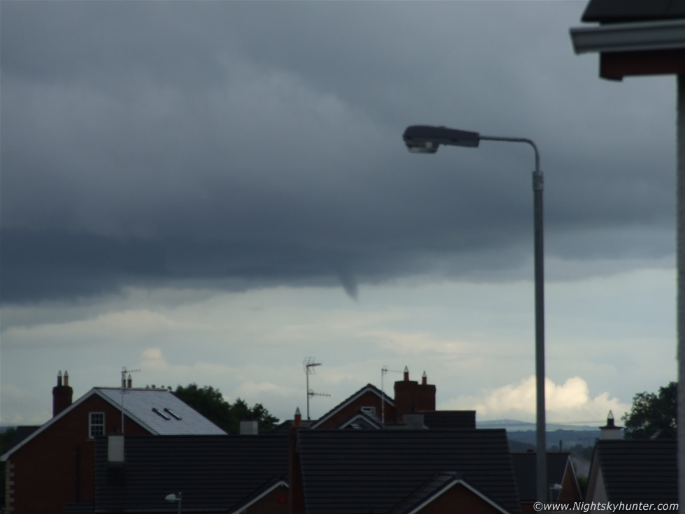 |
When I first saw it I was amazed to see that this substantial looking funnel extended half way to the ground!. Even at that distance I could see it rotating like crazy. It began to slowly retract upwards again. I took the wide angle lens off, rushed over to the window, and gripped by panic I swung the window open, rested the camera on the ledge and began to zoom and get focused as best I could.
 |
The funnel was quite dark and very well formed with smooth edges. It's lowest tip was constantly changing shape as the tuba rotated. The condensation funnel looked quite solid. At times the bottom looked ragged, then a thick tube with a long, thin, needle-like thread extended out, then it all smoothed out. You can see the striations in the base of the cell. I first noticed it before 19.00 BST and I estimate that it lasted for about 5 min's in duration. I managed to get 11 images and a very short video clip. I didn't have the aperture closed down to get depth of focus so while trying the best I could under the circumstances to get the funnel in focus the foreground and background were out of focus. I wonder what this funnel was doing before I turned around on my chair and for how long it was visible for. It could even have been on the ground for all I knew although I'm sure someone would have seen it. It would have quite a distance to drop to make contact and become a tornado.
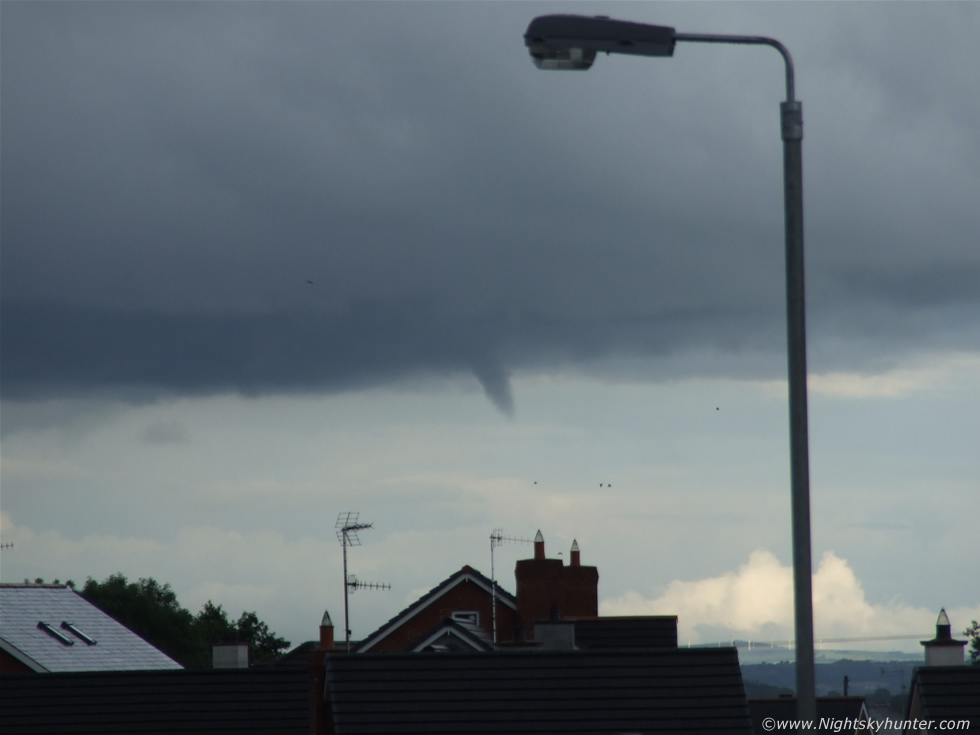 |
It was a beauty though. Still images do not capture the experience of seeing one of these things in the flesh. Your heart is pumping, the adrenaline is flowing through your body, you have tunnel vision, and your panicking about getting an image as your mind gets bombarded by hundreds of thoughts at the same time. Funnel clouds look spectacular when you have your own encounter with one. They have that striking alien look, like they are not supposed to be there. I can feel the excitement even now as I relive the event in my mind. You can see the eastern horizon in the lower right of the image with a distant wind farm and towering Cu aloft.
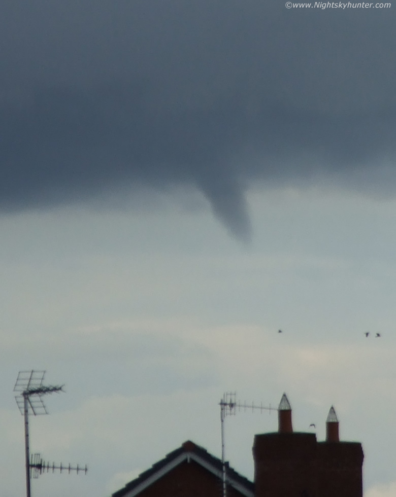 |
Deep crop in close with distant Birds flying near the funnel
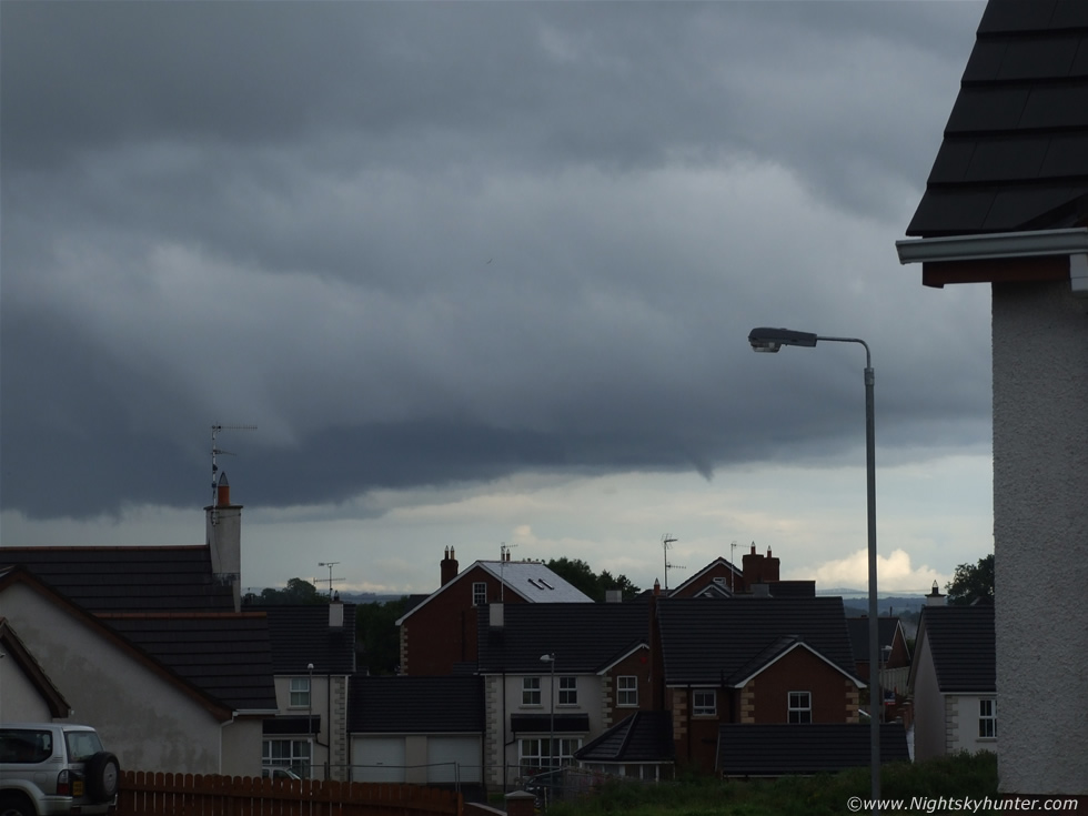 |
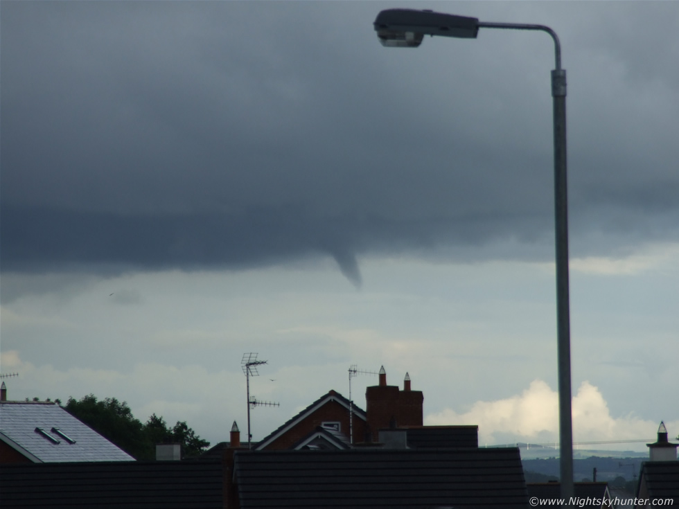
Wide shot showing the funnel retreating back up into the cloud base. I so wish I had turned around on my chair one min earlier. Had I have done so I would have an image of the funnel half way to the ground. I was laughing to myself at the same time because I had spent an incredible amount of time all year looking for these then here I am looking at one from my bedroom window!. The funnel continued rotating and vanished back into the cloud base like a Bear going back to its cave.
This is the only video I got. It was taken as the funnel was retracting and at its least spectacular stage. If you look closely you can see it rotating despite the compression. Watching a funnel decay is a very exciting stage because they can do so in a variety of ways. They can retract back into the base which this one did, they can fizzle out, or they can rope out. I was on quite a high after this and sent a few text messages out. The multicells which produced it where further away but still visible so I went out and watched them for a period just incase another funnel formed.
It pretty much rained all night after these images was taken, torrential at times too. I didn't care because I was on an absolute high!. To be honest, I didn't exactly compose myself, nobody was home so I shaked my fists in the air and yelled ''I caught a funnel''. I tried to tell my Dogs but they didn't understand. I uploaded the images and reported the sighting. TORRO was aware of the funnel within min's after it happened.
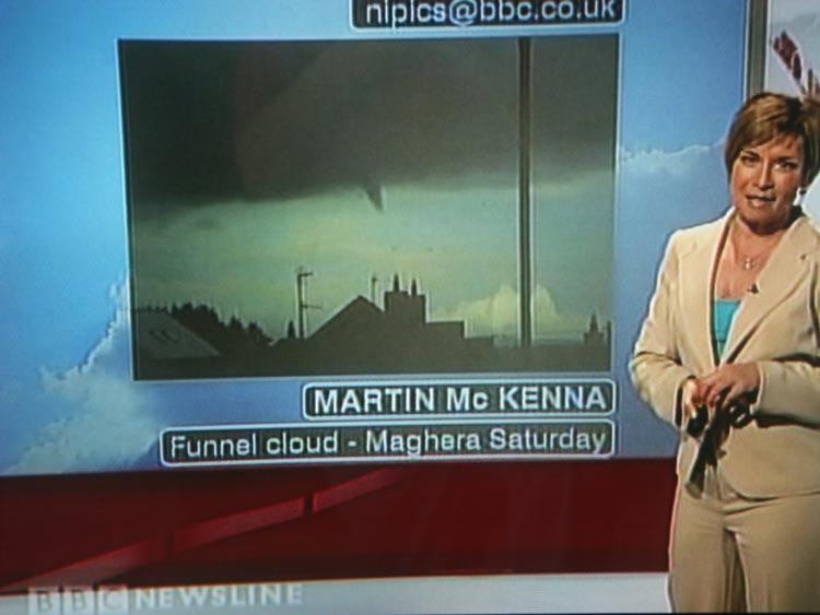 |
Here's my image the following day on the BBC Newsline N. Ireland television weather report. Thanks to Paul Evans from Larne for getting this screen grab for me. August 1st and 2nd have completely turned this season around. Beforehand I was getting very little results despite my extreme efforts all year. Everything seemed to have changed since the partial solar eclipse. The last two days have produced some great stuff.
August 1st - Solar Eclipse and Maghaberry funnel cloud followed by the Maghera Mesocyclone (report) that same evening. Funnel cloud also seen from Ballymena.
August 2nd - Cool gust front followed by this funnel cloud.
At the time of writing (8th) there have been three funnels reported in the Republic of Ireland and a possible tornado in North Wales. There's lots going on!.
I have been very lucky because this marks my 6th or 7th funnel cloud observed and imaged in just over a year. Here are a couple of accounts the others..
July 17th 2007
http://www.nightskyhunter.com/Funnel%20Cloud%20-%20July%2017th%202007.html
July 21st 2007
http://www.nightskyhunter.com/Funnel%20Cloud%20-%20July%2021st%202007.html
I don't have reports of the others because I only had a few images taken at the time. On July 18th 2007 my Mum and I happened to witness Sister funnels rotating over the Coleraine Road on our way back from Portrush. I got a few images through the car window. We passed under the dark base of a large Cb which produced a t-storm, heavy rain, and hail. The updraught had knocked both funnels into a horizontal configuration under the base. Had their been weak inflow the funnels would have hung down vertically above the road and traffic. I seen another small funnel on August 1st this year and got images. This was tiny and unimpressive so I never showed anyone the images. This (August 2nd) funnel is my second best. My favourite was the July 17th 2007 monster funnel which remains to this day the most exciting phenomena I have seen in daylight. It also generated an investigation by TORRO which resulted in me meeting tornado researcher Dr. John Tyrrell. I will never forget the stories and informatiion he gave me over those two days. I would love to beat the July 17th funnel, it would be difficult to do but since I'm the optimistic sort I fully intend do to just that. My primary goal is to catch a tornado on the ground in N. Ireland.
If you have never seen a good funnel cloud before then believe me you will want to. Words cannot describe the phenomena so first hand experience is the key. You will know what I mean when you see one. According to TORRO, Ireland gets an average of 9 tornadoes each year. They are most prolific during the Summer months however the more powerful tornadoes form during Winter despite their fewer numbers. Funnel clouds must greatly out number tornadoes so there's a higher chance of catching one of these. They can appear at any time of the year but most are seen in Summer. To increase your chances of catching one, learn to identify the different kind of cells which can produce them, study every convective forecast and pay particular attention to wind shear and convergence zones, always watch the sky and most important of all...never never give up!. Here's some funnel info from Wikipedia...
A funnel cloud is a funnel-shaped cloud of condensed water droplets, associated with a rotating column of air and extending from the base of a cloud (usually a cumulonimbus or towering cumulus cloud) but not reaching the ground or a water surface. A funnel cloud is usually visible as a cone-shaped or needle like protuberance from the main cloud base. Funnel clouds frequently form in association with supercell thunderstorms. If a funnel cloud touches the ground it becomes a tornado. Most tornadoes begin as funnel clouds, but many funnel clouds do not make ground contact and so do not become tornadoes. Also, a tornado does not necessarily need to have an associated condensation funnel—if strong cyclonic winds are occurring at the surface, then the feature is a tornado. Some tornadoes may appear only as a debris swirl, with no obvious funnel cloud extending below the rotating cloud base. A funnel cloud that touches down on, or moves over water is a waterspout.
Cold-air (or cold-core) funnel clouds are usually short-lived and generally much weaker than the vortices produced by supercells. Although cold-air funnels rarely make ground contact, they may touch down briefly and become weak tornadoes or waterspouts. Unlike the related phenomenon associated with severe thunderstorms, cold-air funnels are generally associated with partly cloudy skies in the wake of cold fronts, where atmospheric instability and moisture is sufficient to support towering cumulus clouds but not precipitation. The mixing of cooler air in the lower troposphere with air flowing in a different direction in the middle troposphere causes the rotation on a horizontal axis, which, when deflected vertically by atmospheric conditions, can become a funnel cloud. They are a common sight along the Pacific Coast and USA, particularly in the spring or autumn.
Martin McKenna